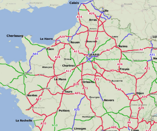
Driving on highways is different wherever one travels. The US has large expanses of land, and most major cities have many miles between them, hence national highways are sort of laid out and numbered in a grid pattern. Look at national maps for even the largest European countries, like France and Germany, and it can look like that pot of spaghetti you spilled on the kitchen floor while trying to “help” your mom when you were 9 years old.

It’s OK. You felt bad when you spilled dinner, but mom made it a learning experience and you are a better person for it. Now we’re going to make a little sense of those European “spilled spaghetti” highway maps.
Although these countries individually generally do not lend themselves to a US-style grid and grid-number system, both because of history and geography, they do indeed have patterns. These are not very useful, if you want my biased opinion. Well, perhaps useful for rote memorization.
European countries all have several “levels” of highway, just as in the US. And each level will carry different amounts of traffic, depending on demand and the level. For example, in the US, the Interstate Highway system has very high demand, and has the highest standard. Although comprising only about 1% of all US highways by mileage, the Interstate highways carry 25% of highway traffic by vehicle miles. That’s astounding. A little more on this later.
I’ll use the two largest European countries, France and Germany, as examples here (um, “largest” not counting Russia). Each also, naturally, has multiple levels of highway. Or Classes. Each has an “A”, or top level “motorway.” In Germany the A stands for Autobahn. Of course. In France it is A for an Autoroute. These are limited access, high speed, and high standard roadways; in France there is often a toll involved – and they are quite expensive.
Each has a second-tier highway as well. In France, it’s the N highways, or Route Nationale. Germany’s second-tier are “B” (which makes more sense, B following A), for Bundesstraßen – or Federal Roads. These are often quite nice as well.
Speaking of expensive. Beware of radar speed detectors, especially on the B or N roads. Speed limits rise and fall rapidly around mid- and smaller-sized cities. Where it falls suddenly – often with scant warning – there is almost sure to be an automatic radar speed detector. If you flinch when you see a sudden flash (usually blue), you’ve been nicked. Your car rental company will make sure you get all of these resulting traffic tickets, while the ticket processing fees are inevitably pinned to your credit card. Sneaky European bastards. You can generally ignore the tickets themselves; they make nice wallpaper, or fire starters, tools to study another language, whatever. (I hear Italy is the absolute worst). The money grabbers, er, ah, traffic officials will try to collect for about 6 months. Ignore them. They will give up…eventually. But the processing fees for the car hire company are unavoidable. Those cost about $25 a pop.
As much of the highway patterns initially look like spilled spaghetti to an American European-car-vacation beginner, one cannot imagine at first that there is a numbering pattern. The routes generally link larger cities and often follow – or run roughly parallel to – centuries’ old trade routes. Often newer, higher standard “A” routes run near the “B” or “N” routes, but bypassing the snarled urban areas. But … an actual numbering pattern?
Well, of course there is a pattern. We are talking Germans here. How could Germans not have a pattern? And the French would hate to be outdone by their European rival brother.

In both countries highway number sequences are assigned by region. It’s that simple. In France, the major highways near Paris seem to get most of the lower numbers; and they sort of radiate out from there, like crooked spokes on a banged up old bicycle wheel. In Germany the single digit “A” autobahn highways have single digit numbers if they run across the entire country – border-to-border, so to speak. The rest are assigned by region: for example, any Autobahn in Bavaria has an ID number in the 90s.
Yet, the Europeans have demonstrated a sort of “Highway-Pattern-and-Numbering-Envy”. “Envy of whom?” you ask. Of course, the United States.
___________________________________________________________________
In September 1925 – nearly a century ago – a small committee of national highway officials met at the Jefferson Hotel in downtown St. Louis. One of their tasks? To assign numbers to the new federal highway system. Other related tasks involved national highway standards: e.g. widths, grades, surfaces, signs and markings. This would become the US Highway system.
Until then, as in Europe, major roads – and later highways – followed older trails: in the US either old Amerindian, pioneer or fur trade routes. And, to make it complicated, each state had their own system for numbering highways (sometimes letters or names), even if they “linked up” with a highway in an adjoining state. They were twisted too; they often directed motorists on less than efficient paths, in order to promote commerce in remote, but politically well-connected, towns and villages. [many US highways retain these rather anachronistic vestiges, wandering through downtown and business sectors of towns, villages and cities].
Well, in what seems to have been accomplished in a single day, September 25th, a small committee of five Chief State Engineers (from Illinois, Missouri, Oklahoma, Oregon, and South Carolina) devised the US Highway numbering system. With few exceptions, it’s still in use today.
Ah, the beauty, power and efficiencey of small but powerful committees. China, anyone? Anyhow …
These mighty five decided that highways leading mostly north/south would be assigned odd numbers, with the lowest starting along the east coast. These odd-numbers would increase as you moved west, with the highest odd-numbers being along the west coast. The longest and/or most important N/S routes would end with the number five.
Routes that went mostly East/West would be assigned even numbers; with lower numbers in the north, and increasing to larger numbers in the south. The longest and/or most important E/W routes would end with the number zero. For example: the first transcontinental highway, also called the Lincoln Highway, was US Highway 30.
The beloved and ballyhooed highway from Chicago to Los Angeles, which we know as “Route 66”, was originally to be numbered Route 60. But Kentucky governor William Field wanted the more important sounding 60 to run through his state. Route 66 is officially retired, but signs and the famous song still commemorate “66”, and its representation for our attraction for the open road.
This is the US Highway numbering system still in use today.
A few decades later, in the 1950s, when President Eisenhower got the nationwide super highway system approved (the so-called Interstate Highway System, officially called the “Dwight D. Eisenhower National System of Interstate and Defense Highways”) the numbering scheme for the new system was kept more or less intact. With one major twist.

To avoid number confusion with the US Highway numbers, the lower numbered North/South Interstate routes would be in the west, instead of the east, increasing as the numbering moved east. And the lower numbered East/West routes would be in the south, instead of the north, increasing as the “grid” progressed north. [They wanted no number ambiguity or confusion, which was possible in the middle of the country: fly-over country. So they made a rule that there are no duplicate US numbers and Interstate numbers within the same state. This is the main reason there is no Interstate 50 or 60. And the north/south number confusion was solved by having so many highways in the more densely populated east.]
Although mainly sold as something to facilitate national defense, the Interstate system by far has had its greatest effect on commerce, and next tourism. Up to 80% of the nation’s commercial product (by value and mile) is moved to market, or between suppliers and factories, along Interstate highways. Its effect on individual or family travel: Driving across many states, or the entire nation, has been a summer vacation right-of passage in many families for decades. Many commuters use it as well.

A few asides on the numbering systems. [Recall there is a difference between US Highways (often called “Routes”) and Interstate Highways.]
(1) The US coastal highways do not follow the “5” designation for major N/S routes: US 1 runs along the entire east coast, with US 99 and 101 running along, or near, the west coast. Neither end in a 5. [See add’l map in footnotes].
(2) Three-digit US highway numbers show highways that are sort of alternates to the original: for example, US 287 which passes through my neighborhood, goes north/south through the same regions as US 87. Both go from the CAN-US border in Montana down to the Texas gulf coast. Both US 85 and US 285 also pass near our home. 85 goes from the US-CAN border in North Dakota all the way to the Mexican border in El Paso; 285 branches off from 85 in Denver and winds down to dusty west Texas as well.
(3) For the Interstate system, three digit numbers generally indicate loops or by-passes if the first digit is even (I-405 loops around Seattle, but otherwise is on the I-5 path) or, if the first digit is odd, it denotes spurs that shoot out to facilitate transport and commerce (I-190 in Chicago connects I-90 to O’Hare airport).
___________________________________________________________________
The United Nations was formed in 1945 at the close of World War 2 to help countries peaceably work together. Well, in short order the UN had a commission for pretty much everything. One of those was the UN Economic Commission for Europe (or UNECE).
Around 1950 the UNECE looked first at the many highways in Europe, noting that they – like in the US before the 1925 St Louis Commission – often changed identification as they crossed boundaries. National boundaries in the case of Europe. They noticed the numbering systems were messy and inconsistent. They also anticipated economic growth as recovery from war progressed, which would require more and better roads. The vision was vast, eventually reaching from the UK and Ireland (island nations!) to Central Asia, and beyond … almost to China. A potential for a vast grid and simple, consistent numbering based on the cardinal directions! To wit: Copying the US approach.
These are the “E” highways shown on maps. It is a separately numbered set of highways, much more often than not simply using existing highways. The “E” numbers were just placed alongside the “A” — and in some cases the “B” or “N” — numbers on signs and maps.
With some exceptions, they followed the US example for the “E” highways. Generally North/South are odd; East/West are even. They have secret codes for loops and spurs and local funkiness, just as in the US. The “E” highways are generally “A” class: that is, limited access and high speed. Yeah, there are exceptions, and lots more tedious details, but it’s kinda cool that this system extends from Ireland to Kyrgyzstan. In fact, the E 80 goes from Lisbon to Tokyo!
E highways even span the the North Sea (although the UK refuses to implement them; the M, for Motorway, system is quite satisfactory — you know: Brexit, not using the Euro and all that).

A consistent and logical numbering system for a huge grid of highways. Says the US: You’re welcome. Bitte sehr. Prego. De nada. Molim. Hey, have fun with it. It’s working for us. Hope it continues to work for you.
Until next essay, I wish you safe travels with simple and uncomplicated maps and highways. Yes, even with simple easy to understand highway numbering, keep your GPS/SatNav on and up-to-date.
Peace
Joe Girard © 2020
Note of thanks to John Sarkis for his St Louis history blog, which provided many details and inspired this essay.
For my European friends and family — feel free to make corrections, additions or suggested edits in the comments on the A, B, E, N parts of the essay.
Thanks for reading. As always, you can add yourself to the notification list for when there is newly published material by clicking here. Or emailing joe@girardmeister.com
Extra figure showing US vs Interstate Numbering scheme.

Interstate numbers have low numbers in south and west.
US 10 used to run to Seattle, but was gradually replaced and de-commissioned as I-90 was completed in segments.