I live in Broomfield, Colorado. The main E-W road near me is 120th Avenue. It is also part of US highway 287. When I look at older local maps, being a history nerd, I see the path also carries the label “Cherokee Trail.”
Cherokee? Colorado? Trail of Tears? No. How can that be?
The history of the Cherokees, and their unfair unfortunate fate, is one of those dark chapters in US history that many would rather just gloss over. Yep, that happened. Too bad. Let’s move on. Nothing to learn here.
I won’t do much to change that here, just a bit. The Cherokees, mostly from Georgia, were largely disenfranchised by the white establishment. But they made themselves useful. When a gold rush sprang up in the Appalachian hills of Georgia, they learned how to extract this yellow metal, so loved by whites, and went to work for them.
Then came the Indian Removal Act of 1830. The Cherokee were one of the Five Civilized Tribes — those that had bent toward the European model, hoping assimilation might spare them disdain and deportation. It didn’t work. They were sent west along with the others, on the misnamed Trail of Tears, because “tears” does not even begin to do justice to what happened.
In 1848 gold was discovered at Sutter’s Mill in California. Everyone heard about this, even the Native Amerindian peoples sentenced to a harsh life on a brutal prairie in Indian Territory (which became the state of Oklahoma decades later).
Many had mining skills from their Georgia days, and decided to jump the reservation and head west. They beat a trail, west-by-northwest, into Colorado, then north along the front range of the Colorado Rockies, joining the California and Oregon trails somewhere in Wyoming. The Cherokee Trail.
They became, in effect, Forty-Niners.
One of them is worth following in particular; his life traces the whole shape of this story. Almost better than the trail itself can.
His name was Dennis Wolf Bushyhead. He was born in 1826 near Cleveland, Tennessee (near Chattanooga), the oldest son of the Reverend Jesse Bushyhead, a Cherokee Baptist minister who opposed removal on principle but wouldn’t abandon his people. When the deportation order came, Rev. Jesse chose to lead a detachment of a thousand Cherokee west himself rather than let them make that walk without his spiritual and physical leadership. Dennis was about thirteen. He crossed Tennessee, Kentucky, and Illinois, forded the Mississippi near Cape Girardeau, then crossed Missouri and Arkansas, arriving in Indian Territory in early 1839, just as the worst of the Trail of Tears was finishing.
Gold wasn’t new to the family’s experience even then. It had turned up near a Georgia town called Dahlonega in 1828 — the name comes from the Cherokee word dalanigei, “yellow money” — and Cherokee miners had worked those deposits alongside white prospectors for a decade before removal. The U.S. Mint opened a Dahlonega branch in 1838, the same year the last Cherokee were marched out of the state. So when word reached Indian Territory in 1848 that gold had turned up again, three thousand miles further west this time, it landed on people who already had a complicated, working relationship with what that kind of news could mean.1
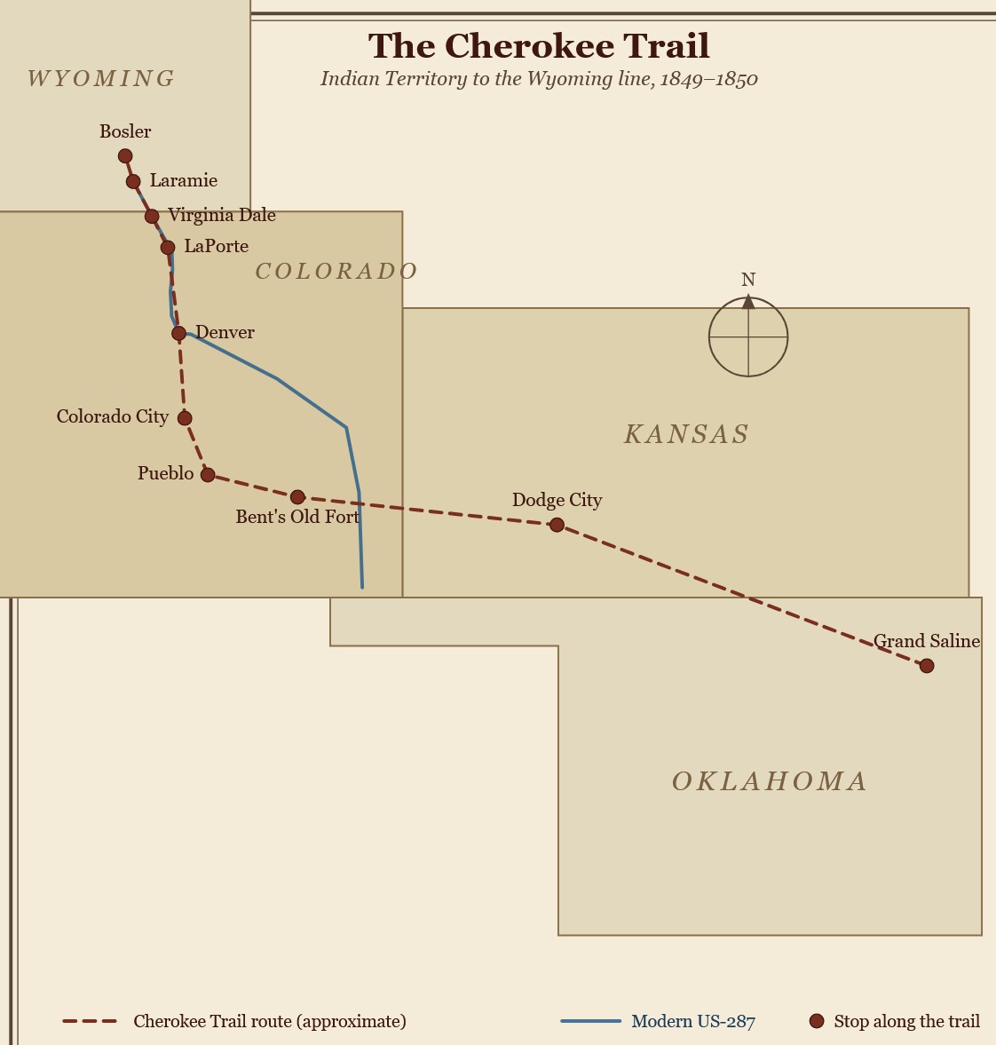 The trail had a name before the Cherokee gave it one. Lieutenant Abraham Buford marked out a version of it in 1848. The next year a mixed party — Cherokee families and white farmers from Washington County, Arkansas — rendezvoused at the Grand Saline salt works and headed west under a captain named Lewis Evans. They picked up the Santa Fe Trail, followed the Arkansas River to the ruins of Bent’s Fort, then turned north through Pueblo along an old Ute route past Manitou Springs and Colorado City — Colorado Springs country now — before reaching the Denver area and continuing north toward Fort Laramie and eventually Fort Bridger, Wyoming, where the road met the California and Oregon trails.2
Dennis Wolf Bushyhead was part of the wave that followed in 1850, in his early twenties by then. Records from that season are thin and sometimes contradict each other about exactly which company he traveled with; the record-keeping habits of the mid-nineteenth century weren’t built with people like Cherokees in mind. What survives points to the same emigration season as a Cherokee diarist named John Lowery Brown, whose journal is the best firsthand account of that year’s crossing. It is not an easy read. Brown records graves dug along the trail almost every day — men dead of dysentery, of cholera, of what he simply calls “the diarear.” A young Cherokee named George Martin, nephew of the Cherokee Nation’s first chief justice, died and was buried in a canyon a few miles from camp. The company moved on the next morning; that’s what trail parties did. Historian Hubert Howe Bancroft, writing about that same emigration season more broadly, described wagon trains further down the route reduced to walking wounded — starving, on foot, drinking from alkaline pools that made things worse, not better.3
Somewhere in that grim traffic, according to a note attached to the Gilcrease Museum’s copy of Brown’s journal, Bushyhead was among a group of Cherokees who took it on themselves to bury every person who died along the trail — not just their own, but everyone regardless of whose company they’d started in. This was without ceremony. It was a shovel, a hole, and doing it again the next day, for strangers, on a trail that was killing people constantly. If we want a hero for this story, that’s where I’d point. Not a battle, not a speech. Just showing up.4
June 22, 1850, is the day this same emigration season earned its footnote in Colorado history, and it’s worth including because it’s the one piece of this trail most Denver-area people already half-know. Camped where a small stream fed into Clear Creek, a few miles west and north of what’s now Denver, a member of one of these wagon trains named Lewis Ralston dipped a pan and came up with color. Yellow. Ralston wasn’t Cherokee — he was Irish, married to a woman with Cherokee ancestry, and had joined a wagon train after showing up in Indian Territory hoping to make his fortune out west. A few others panned the same water and came up with flakes, not much else. Not enough to stop for. The company decided California would pay better and moved on. The creek kept Ralston’s name anyway, and countless Coloradans now drive past it without a second thought.5
Bushyhead never struck it rich in California; neither did most of the Cherokee who went west with him. The record thins out once the wagons scattered into the mining camps. A camp in the Sierra foothills, now Nevada County, took the name Cherokee after a party of Cherokee miners started working it in 1850, and grew to some four hundred people by 1852 — proof some of them did fine, for a while. A handful of other Sierra place names trace back to Cherokee camps that never got that big and left almost nothing else behind. Bushyhead gave up on mining and found newspaper work, first in the Sierra foothills, later in San Diego with his younger brother Ned. It was honest work, if not the fortune he’d come for.6
They’d arrived, both of them, in a place already being emptied out by the same rush that had emptied out their own homeland twenty years before. California’s Native Amerindian population — Nisenan, Maidu, and dozens of other Native peoples whose ground the gold camps sat on — was somewhere near 150,000 in 1848. By 1870 it was under 30,000. This dramatic decline wasn’t due to drought or disease alone. California’s first governor, Peter Burnett, told the state legislature in 1851 (it became the 31st state in 1850) that a war of extermination between the races would go on until the Indian race was extinct, and the state backed that up with cash — bounties on Native scalps. (Some sources dispute this, but not Burnett’s overt racism). The Cherokee, who came west as simply gold-seekers among gold-seekers, received the same rough tolerance as any other broke prospector — which wasn’t much. None of it extended to the people on whose land the goldfields actually were.7
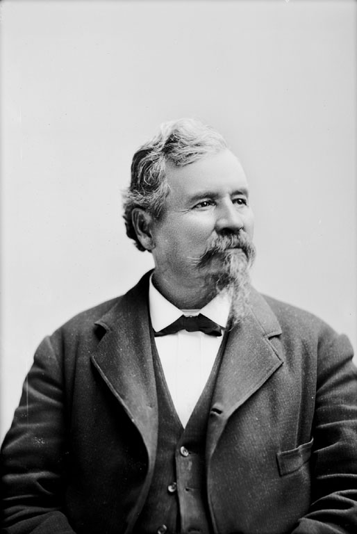
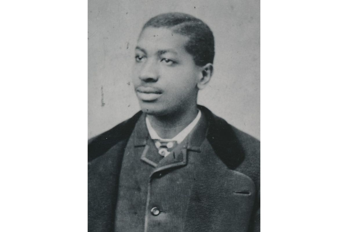
Dennis Wolf Bushyhead, circa 1875
Bushyhead didn’t get back to Indian Territory until 1868, eighteen years later. What he did with the rest of his life was to be of service. He served as treasurer of the Cherokee Nation, then in 1879 was elected Principal Chief, a post he held for two terms. Much of that office was spent fighting off railroad companies angling for right-of-way through Cherokee land — the same sort of encroachment, in a different generation’s clothes, that had pushed him, his father and their people out of Georgia. He wasn’t a saint about it, either, which is noteworthy for its boldness: in 1883 he vetoed a Cherokee Senate bill that would have cut Cherokee Freedmen out of a federal compensation payment, reminding the council of an 1866 treaty promising Freedmen full citizenship — and the council overrode his veto anyway. He didn’t win that one. But he was on record trying.8
Meanwhile the trail he’d once walked kept running, a major road for prospectors, freight, and mail through the rest of the 1850s. Eight years after his accidental strike, Lewis Ralston came back to Colorado with a Georgia prospector named William Green Russell, and this time they found enough yellow flakes and chunks on nearby Dry Creek to really matter. Word raced east that fall and touched off the Pikes Peak (Colorado) Gold Rush, putting about a hundred thousand people on the road west within three years. Members of Russell’s party founded Auraria that same year, on the ground that became Denver — ground that belonged, by an 1851 treaty, to the Arapaho and Cheyenne (according to descendants, the land was theirs “as long as the grass grows and the rivers flow,” although that exact verbiage – verbally promised – was not in the treaty—which they couldn’t read anyway; that’s what they were told). That treaty was worthless within a couple of years of the strike. By 1861 their land had been renegotiated down to a tiny fraction of its size, signed by only a handful of chiefs who never got most of their people to agree to it. Three years after that, on November 29, 1864, came Sand Creek, in Colorado’s southeastern plains — Chivington’s Colorado militia surprise attack against a largely unarmed camp flying both a U.S. flag and a white one, somewhere between 150 and 400 people dead, most of them women, children, and the elderly. It’s usually taught as its own isolated horror. It had a paper trail running back through broken treaties to a lucky pan of gold on a creek that still carries an Irishman’s name.9
Once the emigrant wagon trains thinned out, the western branch through Broomfield got a second life as a scheduled stagecoach route. Farmers and ranchers worked the land along it, selling crops and supplies to the mining towns and travelers passing through. The corridor filled in with stage stations — Church’s Ranch near today’s Old Wadsworth and 105th in Westminster; Boon’s Ranch at Boulder Creek; a station north of what’s now Longmont. The towns themselves came later — Longmont in 1871, Lafayette in 1888, Broomfield’s first rail stop in 1885 — they grew up on the same ground the ranches had already staked out, for the same reasons: water, and a road. Broomfield itself wasn’t incorporated until 1961. Within twenty years of the stage line’s arrival, the railroad had made the whole trail obsolete.10
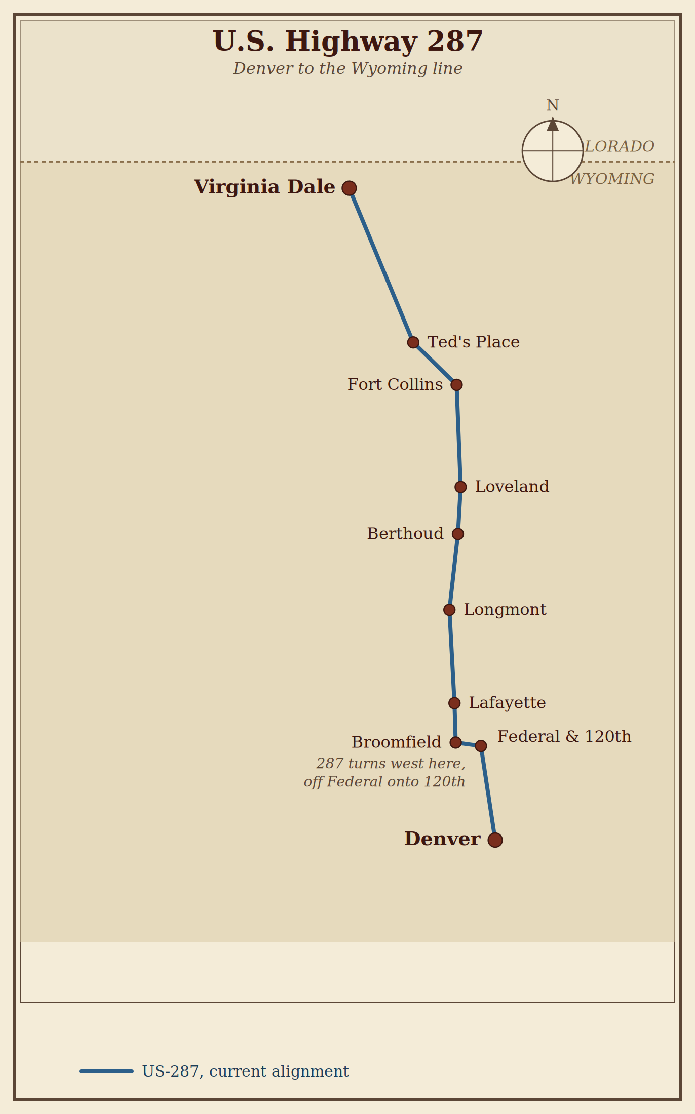
US 287 Denver to Wyo, the little E-W segment is near my home
Which brings us back to U.S. Highway 287 along 120th Avenue. I drive this stretch of road several times a week, usually preoccupied with modern suburban reality. In urban planning terms, 120th Avenue is a classic “stroad”—that awkward, forced marriage between a high-speed road meant to move traffic between cities, and a commercial street meant to serve as a distributor to destinations. By trying to be both, it fails at both: high speed limits punctuated by endless traffic lights; dangerous merge lanes; red-light runners; and all sorts of businesses and rows of strip malls bleeding onto a US highway.
It is 21st-century suburban sprawl built right over a 19th-century passage. It is easy to forget that this frustrating commute lies directly over a historic corridor—one traveled by displaced families, fortune-seekers, and a Cherokee minister’s son who paused to bury strangers along the way.
I can’t claim to match Dennis Wolf Bushyhead’s legacy of compassion, advocacy and leadership, but whenever I drive 120th Avenue now, at least I know whose road I’m on.
Cherokee Trail.
Joe Girard © 2026
Thank you for reading. As always, you can add yourself to the notification list for newly published material by clicking here . Or emailing joe@girardmeister.com
* * *
Notes
1 Dahlonega’s 1828 gold discovery and the Cherokee word dalanigei: “Gold Rush,” New Georgia Encyclopedia, georgiaencyclopedia.org; City of Dahlonega, “About Our Town,” dahlonega.gov.
2 On Lt. Buford’s 1848 route and the 1849 Evans wagon train: “Cherokee Trail,” Wikipedia; “Cherokee Trail — An Alternate Route to the West,” Legends of America, legendsofamerica.com.
3 John Lowery Brown’s journal is transcribed in full in Muriel H. Wright, “The Journal of John Lowery Brown, of the Cherokee Nation En Route to California in 1850,” Chronicles of Oklahoma 12, no. 2 (June 1934): 177–213, available through the Oklahoma Historical Society’s Gateway to Oklahoma History. The original manuscript is held by the Gilcrease Museum, Tulsa.
4 The burial detail comes from an annotation accompanying the Gilcrease Museum’s copy of Brown’s journal (collections.gilcrease.org). Records for the 1850 season are otherwise thin on exactly which company Bushyhead traveled with.
5 On Ralston’s June 22, 1850 discovery and his background — Irish, married to a woman of Cherokee ancestry: Legends of America, “Cherokee Trail”; 9News, “Ralston Discovers Gold in the Arvada Region in 1850,” June 2015.
6 On the Nevada County mining camp: “Cherokee, Nevada County, California,” Wikipedia. On Bushyhead’s California years and newspaper work: “Dennis Bushyhead,” Wikipedia; “Bushyhead, Dennis Wolfe,” The Encyclopedia of Oklahoma History and Culture, Oklahoma Historical Society, okhistory.org.
7 Population figures and Governor Burnett’s 1851 address: “California’s Little-Known Genocide,” History.com; “California genocide,” Wikipedia, citing Benjamin Madley, An American Genocide: The United States and the California Indian Catastrophe, 1846–1873 (Yale University Press, 2016). Note: a 2023 California History journal article disputes the specific claim that the state paid cash bounties for scalps, arguing state funds instead went to reimbursing militia expeditions; the population collapse and Burnett’s quoted language are not in dispute.
8 “Dennis Bushyhead,” Wikipedia; “Bushyhead, Dennis Wolfe,” The Encyclopedia of Oklahoma History and Culture, Oklahoma Historical Society.
9 On the 1858 strike, Auraria, and the Fort Laramie and Fort Wise treaties: Colorado Encyclopedia, “Colorado Gold Rush” and “City and County of Broomfield,” coloradoencyclopedia.org.
10 On stage stations and early settlement along the trail: Lafayette History Project, “The Overland and Denver-to-Cheyenne Stagecoach Lines,” lafayettehistory.com; Colorado Encyclopedia, “Overland Trail in Colorado”; “Overland Trail,” Wikipedia.